|
|
|||||||||||||||||
| Point ID: 377 | Downloads | Plots | Site Data | Code: 05CC009 |
|
|
|||||||||||||||||
| Download | |
|---|---|
| Site Descriptor Information | Site Time Series Data |
| Link to all available data | |
| View: | Time Series | All |
| Units: | mm |
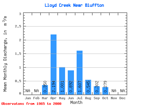
| Statistic | Jan | Feb | Mar | Apr | May | Jun | Jul | Aug | Sep | Oct | Nov | Dec | Annual |
|---|---|---|---|---|---|---|---|---|---|---|---|---|---|
| Mean | 0.35 | 2.19 | 1.00 | 0.89 | 1.61 | 0.55 | 0.30 | 0.28 | |||||
| Standard Deviation | 0.38 | 1.89 | 0.88 | 1.03 | 2.13 | 0.61 | 0.30 | 0.21 | |||||
| Min | 0.00 | 0.24 | 0.09 | 0.05 | 0.01 | 0.03 | 0.00 | 0.00 | |||||
| Max | 1.80 | 8.25 | 3.45 | 4.93 | 8.95 | 3.02 | 1.43 | 0.81 | |||||
| Coefficient of Variation | 1.08 | 0.86 | 0.88 | 1.15 | 1.32 | 1.12 | 0.99 | 0.77 |
 Return to R-Arctic Net Home Page