|
|
|||||||||||||||||
| Point ID: 377 | Downloads | Plots | Site Data | Code: 05CC009 |
|
|
|||||||||||||||||
| Download | |
|---|---|
| Site Descriptor Information | Site Time Series Data |
| Link to all available data | |
| View: | Time Series | All |
| Units: | m3/s |
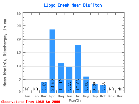
| Statistic | Jan | Feb | Mar | Apr | May | Jun | Jul | Aug | Sep | Oct | Nov | Dec | Annual |
|---|---|---|---|---|---|---|---|---|---|---|---|---|---|
| Mean | 3.89 | 23.60 | 11.13 | 9.59 | 17.85 | 6.06 | 3.25 | 3.10 | |||||
| Standard Deviation | 4.20 | 20.30 | 9.74 | 11.05 | 23.65 | 6.78 | 3.22 | 2.38 | |||||
| Min | 0.00 | 2.60 | 1.04 | 0.54 | 0.14 | 0.33 | 0.00 | 0.00 | |||||
| Max | 20.00 | 88.73 | 38.34 | 53.02 | 99.45 | 33.56 | 15.38 | 9.06 | |||||
| Coefficient of Variation | 1.08 | 0.86 | 0.88 | 1.15 | 1.32 | 1.12 | 0.99 | 0.77 |
 Return to R-Arctic Net Home Page