|
|
|||||||||||||||||
| Point ID: 376 | Downloads | Plots | Site Data | Code: 05CC008 |
|
|
|||||||||||||||||
| Download | |
|---|---|
| Site Descriptor Information | Site Time Series Data |
| Link to all available data | |
| View: | Time Series | All |
| Units: | mm |
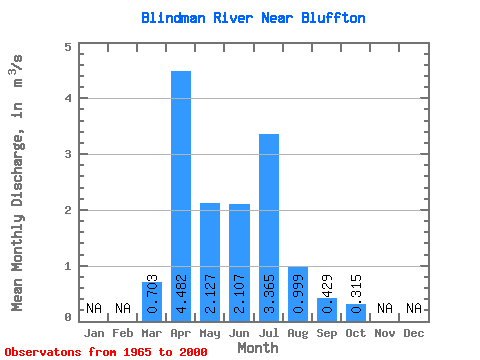
| Statistic | Jan | Feb | Mar | Apr | May | Jun | Jul | Aug | Sep | Oct | Nov | Dec | Annual |
|---|---|---|---|---|---|---|---|---|---|---|---|---|---|
| Mean | 0.70 | 4.48 | 2.13 | 2.11 | 3.37 | 1.00 | 0.43 | 0.32 | |||||
| Standard Deviation | 0.78 | 3.94 | 1.88 | 3.03 | 4.77 | 1.68 | 0.76 | 0.39 | |||||
| Min | 0.01 | 0.38 | 0.04 | 0.01 | 0.04 | 0.01 | 0.00 | 0.00 | |||||
| Max | 2.70 | 15.90 | 6.65 | 11.70 | 20.90 | 7.94 | 4.21 | 1.89 | |||||
| Coefficient of Variation | 1.11 | 0.88 | 0.88 | 1.44 | 1.42 | 1.68 | 1.77 | 1.24 |
 Return to R-Arctic Net Home Page