|
|
|||||||||||||||||
| Point ID: 376 | Downloads | Plots | Site Data | Code: 05CC008 |
|
|
|||||||||||||||||
| Download | |
|---|---|
| Site Descriptor Information | Site Time Series Data |
| Link to all available data | |
| View: | Time Series | All |
| Units: | m3/s |
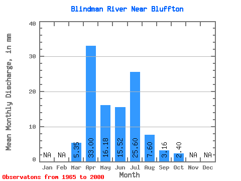
| Statistic | Jan | Feb | Mar | Apr | May | Jun | Jul | Aug | Sep | Oct | Nov | Dec | Annual |
|---|---|---|---|---|---|---|---|---|---|---|---|---|---|
| Mean | 5.35 | 33.01 | 16.18 | 15.52 | 25.60 | 7.60 | 3.15 | 2.39 | |||||
| Standard Deviation | 5.93 | 29.04 | 14.27 | 22.32 | 36.26 | 12.74 | 5.60 | 2.96 | |||||
| Min | 0.11 | 2.77 | 0.32 | 0.08 | 0.27 | 0.07 | 0.00 | 0.02 | |||||
| Max | 20.54 | 117.08 | 50.59 | 86.16 | 159.01 | 60.41 | 31.00 | 14.38 | |||||
| Coefficient of Variation | 1.11 | 0.88 | 0.88 | 1.44 | 1.42 | 1.68 | 1.77 | 1.24 |
 Return to R-Arctic Net Home Page