|
|
|||||||||||||||||
| Point ID: 3695 | Downloads | Plots | Site Data | Code: 10UH002 |
|
|
|||||||||||||||||
| Download | |
|---|---|
| Site Descriptor Information | Site Time Series Data |
| Link to all available data | |
| View: | Time Series | All |
| Units: | mm |
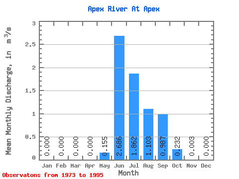
| Statistic | Jan | Feb | Mar | Apr | May | Jun | Jul | Aug | Sep | Oct | Nov | Dec | Annual |
|---|---|---|---|---|---|---|---|---|---|---|---|---|---|
| Mean | 0.00 | 0.00 | 0.00 | 0.00 | 0.15 | 2.69 | 1.86 | 1.10 | 0.99 | 0.23 | 0.00 | 0.00 | 0.53 |
| Standard Deviation | 0.00 | 0.00 | 0.00 | 0.00 | 0.39 | 1.11 | 1.16 | 0.55 | 0.53 | 0.21 | 0.01 | 0.00 | 0.11 |
| Min | 0.00 | 0.00 | 0.00 | 0.00 | 0.00 | 0.46 | 0.38 | 0.18 | 0.15 | 0.02 | 0.00 | 0.00 | 0.44 |
| Max | 0.00 | 0.00 | 0.00 | 0.00 | 1.04 | 4.59 | 4.93 | 2.13 | 2.07 | 0.74 | 0.01 | 0.00 | 0.69 |
| Coefficient of Variation | 2.52 | 0.41 | 0.62 | 0.50 | 0.53 | 0.91 | 1.90 | 0.21 |
 Return to R-Arctic Net Home Page