|
|
|||||||||||||||||
| Point ID: 3695 | Downloads | Plots | Site Data | Code: 10UH002 |
|
|
|||||||||||||||||
| Download | |
|---|---|
| Site Descriptor Information | Site Time Series Data |
| Link to all available data | |
| View: | Time Series | All |
| Units: | m3/s |
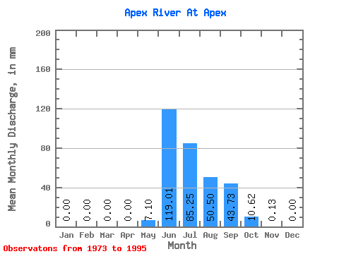
| Statistic | Jan | Feb | Mar | Apr | May | Jun | Jul | Aug | Sep | Oct | Nov | Dec | Annual |
|---|---|---|---|---|---|---|---|---|---|---|---|---|---|
| Mean | 0.00 | 0.00 | 0.00 | 0.00 | 7.11 | 118.99 | 85.22 | 50.49 | 43.71 | 10.63 | 0.11 | 0.00 | 287.30 |
| Standard Deviation | 0.00 | 0.00 | 0.00 | 0.00 | 17.88 | 48.99 | 52.92 | 25.13 | 23.36 | 9.66 | 0.21 | 0.00 | 60.96 |
| Min | 0.00 | 0.00 | 0.00 | 0.00 | 0.00 | 20.25 | 17.35 | 8.19 | 6.82 | 0.96 | 0.00 | 0.00 | 236.84 |
| Max | 0.00 | 0.00 | 0.00 | 0.00 | 47.61 | 203.37 | 225.68 | 97.51 | 91.72 | 34.10 | 0.62 | 0.00 | 369.95 |
| Coefficient of Variation | 2.52 | 0.41 | 0.62 | 0.50 | 0.53 | 0.91 | 1.90 | 0.21 |
 Return to R-Arctic Net Home Page