|
|
|||||||||||||||||
| Point ID: 3693 | Downloads | Plots | Site Data | Code: 10UF001 |
|
|
|||||||||||||||||
| Download | |
|---|---|
| Site Descriptor Information | Site Time Series Data |
| Link to all available data | |
| View: | Time Series | All |
| Units: | mm |
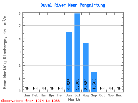
| Statistic | Jan | Feb | Mar | Apr | May | Jun | Jul | Aug | Sep | Oct | Nov | Dec | Annual |
|---|---|---|---|---|---|---|---|---|---|---|---|---|---|
| Mean | 4.53 | 5.91 | 3.68 | 1.50 | |||||||||
| Standard Deviation | 1.49 | 1.08 | 0.89 | 1.47 | |||||||||
| Min | 3.47 | 3.82 | 2.66 | 0.47 | |||||||||
| Max | 5.58 | 7.78 | 4.89 | 3.54 | |||||||||
| Coefficient of Variation | 0.33 | 0.18 | 0.24 | 0.97 |
 Return to R-Arctic Net Home Page