|
|
|||||||||||||||||
| Point ID: 3693 | Downloads | Plots | Site Data | Code: 10UF001 |
|
|
|||||||||||||||||
| Download | |
|---|---|
| Site Descriptor Information | Site Time Series Data |
| Link to all available data | |
| View: | Time Series | All |
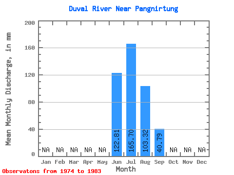
| Units: | m3/s |
| Statistic | Jan | Feb | Mar | Apr | May | Jun | Jul | Aug | Sep | Oct | Nov | Dec | Annual |
|---|---|---|---|---|---|---|---|---|---|---|---|---|---|
| Mean | 122.81 | 165.66 | 103.30 | 40.79 | |||||||||
| Standard Deviation | 40.49 | 30.21 | 24.93 | 39.79 | |||||||||
| Min | 94.18 | 107.12 | 74.59 | 12.73 | |||||||||
| Max | 151.45 | 218.17 | 137.12 | 96.08 | |||||||||
| Coefficient of Variation | 0.33 | 0.18 | 0.24 | 0.97 |
 Return to R-Arctic Net Home Page