|
|
|||||||||||||||||
| Point ID: 3689 | Downloads | Plots | Site Data | Code: 10TF001 |
|
|
|||||||||||||||||
| Download | |
|---|---|
| Site Descriptor Information | Site Time Series Data |
| Link to all available data | |
| View: | Time Series | All |
| Units: | mm |
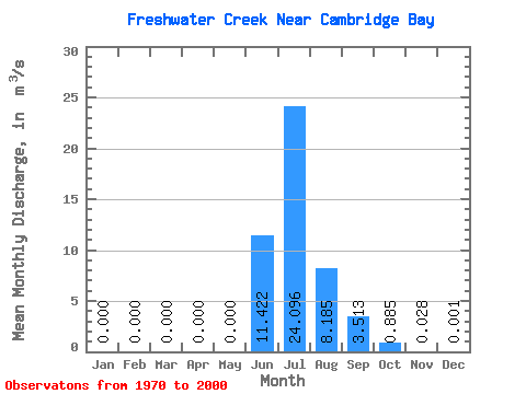
| Statistic | Jan | Feb | Mar | Apr | May | Jun | Jul | Aug | Sep | Oct | Nov | Dec | Annual |
|---|---|---|---|---|---|---|---|---|---|---|---|---|---|
| Mean | 0.00 | 0.00 | 0.00 | 0.00 | 0.00 | 11.42 | 24.10 | 8.19 | 3.51 | 0.89 | 0.03 | 0.00 | 3.89 |
| Standard Deviation | 0.00 | 0.00 | 0.00 | 0.00 | 0.00 | 7.30 | 6.77 | 4.23 | 2.60 | 1.16 | 0.07 | 0.00 | 0.90 |
| Min | 0.00 | 0.00 | 0.00 | 0.00 | 0.00 | 0.01 | 13.70 | 3.26 | 0.98 | 0.07 | 0.00 | 0.00 | 2.56 |
| Max | 0.00 | 0.00 | 0.00 | 0.00 | 0.00 | 25.00 | 38.30 | 24.70 | 11.50 | 5.24 | 0.30 | 0.01 | 6.17 |
| Coefficient of Variation | 0.64 | 0.28 | 0.52 | 0.74 | 1.31 | 2.55 | 3.74 | 0.23 |
 Return to R-Arctic Net Home Page