|
|
|||||||||||||||||
| Point ID: 3689 | Downloads | Plots | Site Data | Code: 10TF001 |
|
|
|||||||||||||||||
| Download | |
|---|---|
| Site Descriptor Information | Site Time Series Data |
| Link to all available data | |
| View: | Time Series | All |
| Units: | m3/s |
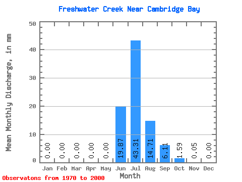
| Statistic | Jan | Feb | Mar | Apr | May | Jun | Jul | Aug | Sep | Oct | Nov | Dec | Annual |
|---|---|---|---|---|---|---|---|---|---|---|---|---|---|
| Mean | 0.00 | 0.00 | 0.00 | 0.00 | 0.00 | 19.87 | 43.31 | 14.71 | 6.11 | 1.59 | 0.05 | 0.00 | 82.33 |
| Standard Deviation | 0.00 | 0.00 | 0.00 | 0.00 | 0.00 | 12.71 | 12.16 | 7.60 | 4.52 | 2.08 | 0.13 | 0.00 | 19.11 |
| Min | 0.00 | 0.00 | 0.00 | 0.00 | 0.00 | 0.02 | 24.62 | 5.86 | 1.70 | 0.12 | 0.00 | 0.00 | 54.31 |
| Max | 0.00 | 0.00 | 0.00 | 0.00 | 0.00 | 43.49 | 68.84 | 44.39 | 20.00 | 9.42 | 0.52 | 0.02 | 130.71 |
| Coefficient of Variation | 0.64 | 0.28 | 0.52 | 0.74 | 1.31 | 2.55 | 3.74 | 0.23 |
 Return to R-Arctic Net Home Page