|
|
|||||||||||||||||
| Point ID: 3686 | Downloads | Plots | Site Data | Code: 10RC001 |
|
|
|||||||||||||||||
| Download | |
|---|---|
| Site Descriptor Information | Site Time Series Data |
| Link to all available data | |
| View: | Time Series | All |
| Units: | mm |
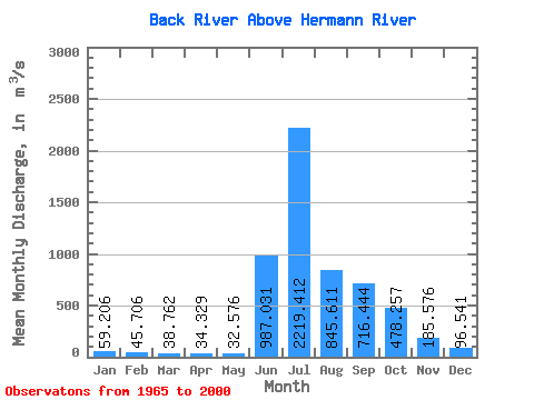
| Statistic | Jan | Feb | Mar | Apr | May | Jun | Jul | Aug | Sep | Oct | Nov | Dec | Annual |
|---|---|---|---|---|---|---|---|---|---|---|---|---|---|
| Mean | 59.21 | 45.71 | 38.76 | 34.33 | 32.58 | 987.03 | 2219.41 | 845.61 | 716.44 | 478.26 | 185.58 | 96.54 | 480.79 |
| Standard Deviation | 17.96 | 12.37 | 9.38 | 8.04 | 7.66 | 622.16 | 782.83 | 229.25 | 327.39 | 236.57 | 79.50 | 34.19 | 86.61 |
| Min | 28.50 | 23.30 | 21.70 | 21.30 | 17.10 | 58.90 | 1000.00 | 409.00 | 370.00 | 193.00 | 84.80 | 46.80 | 355.88 |
| Max | 101.00 | 73.70 | 60.40 | 55.50 | 53.00 | 2090.00 | 4420.00 | 1490.00 | 1790.00 | 987.00 | 347.00 | 166.00 | 727.18 |
| Coefficient of Variation | 0.30 | 0.27 | 0.24 | 0.23 | 0.23 | 0.63 | 0.35 | 0.27 | 0.46 | 0.49 | 0.43 | 0.35 | 0.18 |
 Return to R-Arctic Net Home Page