|
|
|||||||||||||||||
| Point ID: 3686 | Downloads | Plots | Site Data | Code: 10RC001 |
|
|
|||||||||||||||||
| Download | |
|---|---|
| Site Descriptor Information | Site Time Series Data |
| Link to all available data | |
| View: | Time Series | All |
| Units: | m3/s |
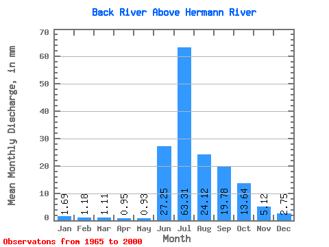
| Statistic | Jan | Feb | Mar | Apr | May | Jun | Jul | Aug | Sep | Oct | Nov | Dec | Annual |
|---|---|---|---|---|---|---|---|---|---|---|---|---|---|
| Mean | 1.69 | 1.19 | 1.10 | 0.95 | 0.93 | 27.25 | 63.30 | 24.12 | 19.78 | 13.64 | 5.12 | 2.75 | 161.60 |
| Standard Deviation | 0.51 | 0.32 | 0.27 | 0.22 | 0.22 | 17.17 | 22.33 | 6.54 | 9.04 | 6.75 | 2.19 | 0.97 | 29.11 |
| Min | 0.81 | 0.60 | 0.62 | 0.59 | 0.49 | 1.63 | 28.52 | 11.66 | 10.21 | 5.50 | 2.34 | 1.33 | 119.61 |
| Max | 2.88 | 1.92 | 1.72 | 1.53 | 1.51 | 57.69 | 126.06 | 42.49 | 49.41 | 28.15 | 9.58 | 4.73 | 244.41 |
| Coefficient of Variation | 0.30 | 0.27 | 0.24 | 0.23 | 0.23 | 0.63 | 0.35 | 0.27 | 0.46 | 0.49 | 0.43 | 0.35 | 0.18 |
 Return to R-Arctic Net Home Page