|
|
|||||||||||||||||
| Point ID: 3685 | Downloads | Plots | Site Data | Code: 10RA002 |
|
|
|||||||||||||||||
| Download | |
|---|---|
| Site Descriptor Information | Site Time Series Data |
| Link to all available data | |
| View: | Time Series | All |
| Units: | mm |
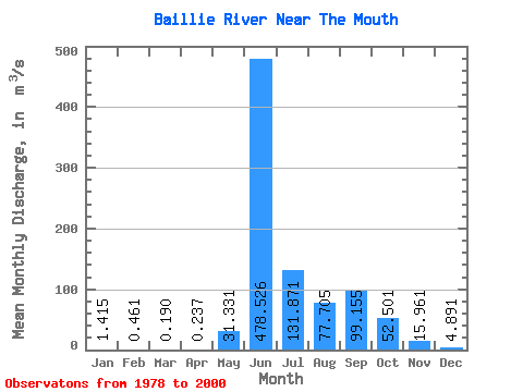
| Statistic | Jan | Feb | Mar | Apr | May | Jun | Jul | Aug | Sep | Oct | Nov | Dec | Annual |
|---|---|---|---|---|---|---|---|---|---|---|---|---|---|
| Mean | 1.42 | 0.46 | 0.19 | 0.24 | 31.33 | 478.53 | 131.87 | 77.70 | 99.16 | 52.50 | 15.96 | 4.89 | 76.54 |
| Standard Deviation | 1.70 | 0.74 | 0.46 | 0.54 | 58.34 | 209.78 | 55.85 | 41.33 | 55.27 | 32.29 | 13.69 | 4.79 | 26.13 |
| Min | 0.00 | 0.00 | 0.00 | 0.00 | 0.59 | 102.00 | 45.70 | 21.80 | 26.80 | 8.33 | 1.51 | 0.00 | 20.13 |
| Max | 4.87 | 2.21 | 1.88 | 1.62 | 170.00 | 837.00 | 248.00 | 195.00 | 213.00 | 122.00 | 51.10 | 14.80 | 112.21 |
| Coefficient of Variation | 1.20 | 1.61 | 2.42 | 2.29 | 1.86 | 0.44 | 0.42 | 0.53 | 0.56 | 0.61 | 0.86 | 0.98 | 0.34 |
 Return to R-Arctic Net Home Page