|
|
|||||||||||||||||
| Point ID: 3685 | Downloads | Plots | Site Data | Code: 10RA002 |
|
|
|||||||||||||||||
| Download | |
|---|---|
| Site Descriptor Information | Site Time Series Data |
| Link to all available data | |
| View: | Time Series | All |
| Units: | m3/s |
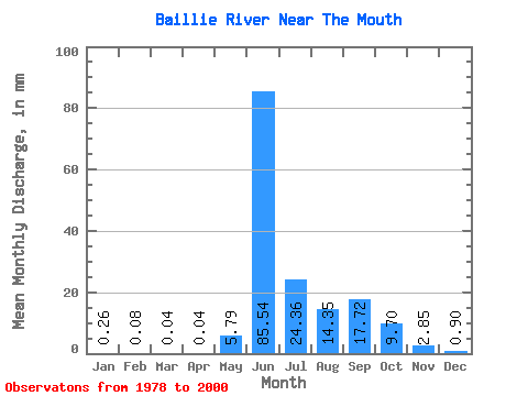
| Statistic | Jan | Feb | Mar | Apr | May | Jun | Jul | Aug | Sep | Oct | Nov | Dec | Annual |
|---|---|---|---|---|---|---|---|---|---|---|---|---|---|
| Mean | 0.26 | 0.08 | 0.04 | 0.04 | 5.79 | 85.54 | 24.36 | 14.35 | 17.73 | 9.70 | 2.85 | 0.90 | 166.59 |
| Standard Deviation | 0.31 | 0.12 | 0.09 | 0.10 | 10.77 | 37.50 | 10.31 | 7.63 | 9.88 | 5.96 | 2.45 | 0.88 | 56.87 |
| Min | 0.00 | 0.00 | 0.00 | 0.00 | 0.11 | 18.23 | 8.44 | 4.03 | 4.79 | 1.54 | 0.27 | 0.00 | 43.82 |
| Max | 0.90 | 0.37 | 0.35 | 0.29 | 31.40 | 149.62 | 45.80 | 36.01 | 38.08 | 22.53 | 9.13 | 2.73 | 244.23 |
| Coefficient of Variation | 1.20 | 1.61 | 2.42 | 2.29 | 1.86 | 0.44 | 0.42 | 0.53 | 0.56 | 0.61 | 0.86 | 0.98 | 0.34 |
 Return to R-Arctic Net Home Page