|
|
|||||||||||||||||
| Point ID: 366 | Downloads | Plots | Site Data | Code: 05CA012 |
|
|
|||||||||||||||||
| Download | |
|---|---|
| Site Descriptor Information | Site Time Series Data |
| Link to all available data | |
| View: | Time Series | All |
| Units: | mm |
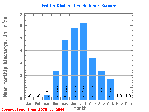
| Statistic | Jan | Feb | Mar | Apr | May | Jun | Jul | Aug | Sep | Oct | Nov | Dec | Annual |
|---|---|---|---|---|---|---|---|---|---|---|---|---|---|
| Mean | 0.41 | 2.33 | 4.84 | 5.81 | 6.18 | 3.42 | 2.33 | 1.68 | |||||
| Standard Deviation | 0.09 | 1.22 | 3.18 | 4.41 | 5.40 | 2.41 | 1.50 | 1.32 | |||||
| Min | 0.34 | 1.24 | 0.80 | 0.80 | 0.53 | 0.39 | 0.57 | 0.63 | |||||
| Max | 0.47 | 5.16 | 11.10 | 19.20 | 18.60 | 8.95 | 5.81 | 6.82 | |||||
| Coefficient of Variation | 0.22 | 0.53 | 0.66 | 0.76 | 0.87 | 0.70 | 0.64 | 0.79 |
 Return to R-Arctic Net Home Page