|
|
|||||||||||||||||
| Point ID: 366 | Downloads | Plots | Site Data | Code: 05CA012 |
|
|
|||||||||||||||||
| Download | |
|---|---|
| Site Descriptor Information | Site Time Series Data |
| Link to all available data | |
| View: | Time Series | All |
| Units: | m3/s |
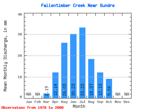
| Statistic | Jan | Feb | Mar | Apr | May | Jun | Jul | Aug | Sep | Oct | Nov | Dec | Annual |
|---|---|---|---|---|---|---|---|---|---|---|---|---|---|
| Mean | 2.19 | 12.14 | 26.02 | 30.24 | 33.23 | 18.37 | 12.13 | 9.03 | |||||
| Standard Deviation | 0.47 | 6.37 | 17.10 | 22.94 | 29.05 | 12.94 | 7.80 | 7.12 | |||||
| Min | 1.85 | 6.45 | 4.28 | 4.15 | 2.82 | 2.12 | 2.96 | 3.38 | |||||
| Max | 2.52 | 26.86 | 59.69 | 99.93 | 100.02 | 48.13 | 30.24 | 36.67 | |||||
| Coefficient of Variation | 0.22 | 0.53 | 0.66 | 0.76 | 0.87 | 0.70 | 0.64 | 0.79 |
 Return to R-Arctic Net Home Page