|
|
|||||||||||||||||
| Point ID: 365 | Downloads | Plots | Site Data | Code: 05CA011 |
|
|
|||||||||||||||||
| Download | |
|---|---|
| Site Descriptor Information | Site Time Series Data |
| Link to all available data | |
| View: | Time Series | All |
| Units: | mm |
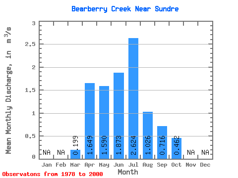
| Statistic | Jan | Feb | Mar | Apr | May | Jun | Jul | Aug | Sep | Oct | Nov | Dec | Annual |
|---|---|---|---|---|---|---|---|---|---|---|---|---|---|
| Mean | 0.20 | 1.65 | 1.59 | 1.87 | 2.62 | 1.03 | 0.72 | 0.46 | |||||
| Standard Deviation | 0.05 | 1.25 | 1.34 | 1.48 | 2.56 | 1.02 | 0.79 | 0.43 | |||||
| Min | 0.14 | 0.50 | 0.19 | 0.21 | 0.04 | 0.03 | 0.09 | 0.11 | |||||
| Max | 0.25 | 4.14 | 4.61 | 6.77 | 7.20 | 4.53 | 3.26 | 1.97 | |||||
| Coefficient of Variation | 0.27 | 0.76 | 0.84 | 0.79 | 0.97 | 1.00 | 1.10 | 0.94 |
 Return to R-Arctic Net Home Page