|
|
|||||||||||||||||
| Point ID: 365 | Downloads | Plots | Site Data | Code: 05CA011 |
|
|
|||||||||||||||||
| Download | |
|---|---|
| Site Descriptor Information | Site Time Series Data |
| Link to all available data | |
| View: | Time Series | All |
| Units: | m3/s |
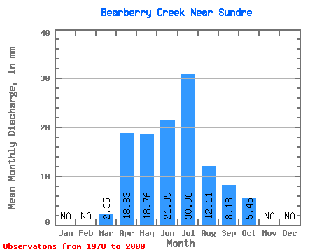
| Statistic | Jan | Feb | Mar | Apr | May | Jun | Jul | Aug | Sep | Oct | Nov | Dec | Annual |
|---|---|---|---|---|---|---|---|---|---|---|---|---|---|
| Mean | 2.12 | 16.97 | 16.89 | 19.27 | 27.89 | 10.90 | 7.36 | 4.91 | |||||
| Standard Deviation | 0.58 | 12.83 | 14.21 | 15.19 | 27.16 | 10.86 | 8.12 | 4.59 | |||||
| Min | 1.51 | 5.11 | 1.98 | 2.16 | 0.40 | 0.28 | 0.90 | 1.16 | |||||
| Max | 2.66 | 42.58 | 48.99 | 69.63 | 76.51 | 48.14 | 33.53 | 20.93 | |||||
| Coefficient of Variation | 0.27 | 0.76 | 0.84 | 0.79 | 0.97 | 1.00 | 1.10 | 0.94 |
 Return to R-Arctic Net Home Page