|
|
|||||||||||||||||
| Point ID: 3646 | Downloads | Plots | Site Data | Code: 10KA007 |
|
|
|||||||||||||||||
| Download | |
|---|---|
| Site Descriptor Information | Site Time Series Data |
| Link to all available data | |
| View: | Time Series | All |
| Units: | mm |
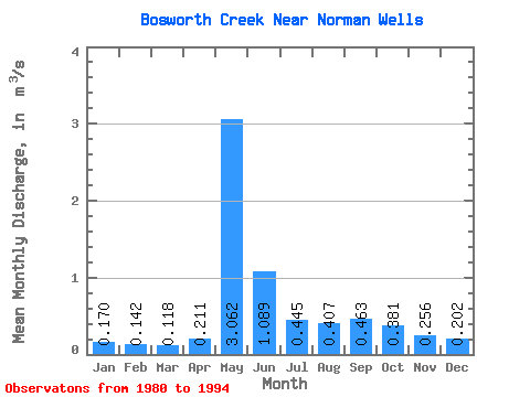
| Statistic | Jan | Feb | Mar | Apr | May | Jun | Jul | Aug | Sep | Oct | Nov | Dec | Annual |
|---|---|---|---|---|---|---|---|---|---|---|---|---|---|
| Mean | 0.17 | 0.14 | 0.12 | 0.21 | 3.06 | 1.09 | 0.45 | 0.41 | 0.46 | 0.38 | 0.26 | 0.20 | 0.58 |
| Standard Deviation | 0.07 | 0.08 | 0.08 | 0.22 | 1.23 | 0.41 | 0.17 | 0.22 | 0.25 | 0.14 | 0.08 | 0.07 | 0.15 |
| Min | 0.08 | 0.07 | 0.06 | 0.07 | 1.59 | 0.52 | 0.31 | 0.20 | 0.22 | 0.24 | 0.14 | 0.09 | 0.42 |
| Max | 0.37 | 0.35 | 0.34 | 0.88 | 6.11 | 1.77 | 0.82 | 1.03 | 1.06 | 0.62 | 0.44 | 0.40 | 0.89 |
| Coefficient of Variation | 0.43 | 0.55 | 0.67 | 1.03 | 0.40 | 0.38 | 0.37 | 0.54 | 0.55 | 0.35 | 0.32 | 0.37 | 0.25 |
 Return to R-Arctic Net Home Page