|
|
|||||||||||||||||
| Point ID: 3646 | Downloads | Plots | Site Data | Code: 10KA007 |
|
|
|||||||||||||||||
| Download | |
|---|---|
| Site Descriptor Information | Site Time Series Data |
| Link to all available data | |
| View: | Time Series | All |
| Units: | m3/s |
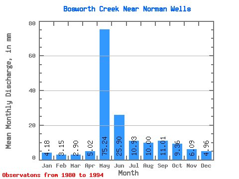
| Statistic | Jan | Feb | Mar | Apr | May | Jun | Jul | Aug | Sep | Oct | Nov | Dec | Annual |
|---|---|---|---|---|---|---|---|---|---|---|---|---|---|
| Mean | 4.19 | 3.17 | 2.90 | 5.02 | 75.23 | 25.90 | 10.94 | 10.01 | 11.02 | 9.35 | 6.10 | 4.97 | 168.22 |
| Standard Deviation | 1.80 | 1.73 | 1.93 | 5.17 | 30.33 | 9.86 | 4.05 | 5.41 | 6.02 | 3.31 | 1.92 | 1.84 | 42.60 |
| Min | 1.99 | 1.59 | 1.38 | 1.55 | 39.06 | 12.41 | 7.54 | 4.84 | 5.30 | 5.92 | 3.21 | 2.21 | 122.36 |
| Max | 9.04 | 7.86 | 8.35 | 21.02 | 150.12 | 42.09 | 20.05 | 25.31 | 25.21 | 15.26 | 10.56 | 9.78 | 257.40 |
| Coefficient of Variation | 0.43 | 0.55 | 0.67 | 1.03 | 0.40 | 0.38 | 0.37 | 0.54 | 0.55 | 0.35 | 0.32 | 0.37 | 0.25 |
 Return to R-Arctic Net Home Page