|
|
|||||||||||||||||
| Point ID: 3645 | Downloads | Plots | Site Data | Code: 10KA006 |
|
|
|||||||||||||||||
| Download | |
|---|---|
| Site Descriptor Information | Site Time Series Data |
| Link to all available data | |
| View: | Time Series | All |
| Units: | mm |
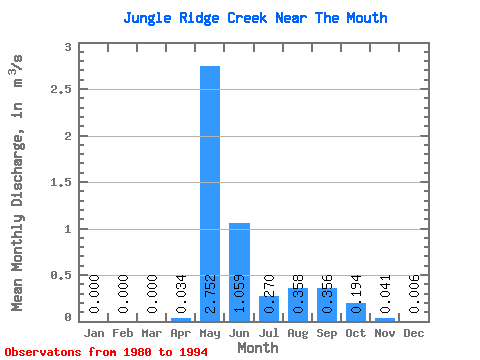
| Statistic | Jan | Feb | Mar | Apr | May | Jun | Jul | Aug | Sep | Oct | Nov | Dec | Annual |
|---|---|---|---|---|---|---|---|---|---|---|---|---|---|
| Mean | 0.00 | 0.00 | 0.00 | 0.03 | 2.75 | 1.06 | 0.27 | 0.36 | 0.36 | 0.19 | 0.04 | 0.01 | 0.42 |
| Standard Deviation | 0.00 | 0.00 | 0.00 | 0.06 | 1.25 | 0.60 | 0.15 | 0.50 | 0.36 | 0.15 | 0.04 | 0.01 | 0.14 |
| Min | 0.00 | 0.00 | 0.00 | 0.00 | 1.04 | 0.34 | 0.11 | 0.05 | 0.08 | 0.04 | 0.00 | 0.00 | 0.22 |
| Max | 0.00 | 0.00 | 0.00 | 0.19 | 4.90 | 2.30 | 0.57 | 1.71 | 1.10 | 0.58 | 0.14 | 0.02 | 0.73 |
| Coefficient of Variation | 1.66 | 0.46 | 0.57 | 0.56 | 1.40 | 1.01 | 0.78 | 0.95 | 1.34 | 0.34 |
 Return to R-Arctic Net Home Page