|
|
|||||||||||||||||
| Point ID: 3645 | Downloads | Plots | Site Data | Code: 10KA006 |
|
|
|||||||||||||||||
| Download | |
|---|---|
| Site Descriptor Information | Site Time Series Data |
| Link to all available data | |
| View: | Time Series | All |
| Units: | m3/s |
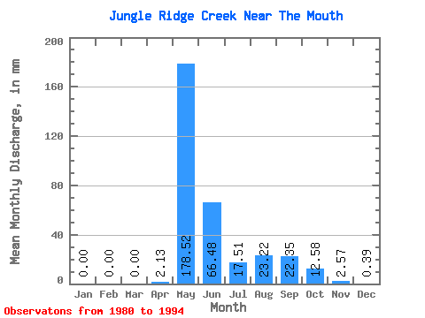
| Statistic | Jan | Feb | Mar | Apr | May | Jun | Jul | Aug | Sep | Oct | Nov | Dec | Annual |
|---|---|---|---|---|---|---|---|---|---|---|---|---|---|
| Mean | 0.00 | 0.00 | 0.00 | 2.10 | 178.51 | 66.45 | 17.49 | 23.22 | 22.34 | 12.59 | 2.56 | 0.37 | 324.20 |
| Standard Deviation | 0.00 | 0.00 | 0.00 | 3.50 | 81.19 | 37.85 | 9.76 | 32.40 | 22.60 | 9.81 | 2.45 | 0.49 | 109.08 |
| Min | 0.00 | 0.00 | 0.00 | 0.00 | 67.45 | 21.53 | 7.33 | 2.98 | 4.77 | 2.53 | 0.06 | 0.00 | 167.39 |
| Max | 0.00 | 0.00 | 0.00 | 11.68 | 317.81 | 144.38 | 36.97 | 110.91 | 69.05 | 37.55 | 8.85 | 1.43 | 561.41 |
| Coefficient of Variation | 1.66 | 0.46 | 0.57 | 0.56 | 1.40 | 1.01 | 0.78 | 0.95 | 1.34 | 0.34 |
 Return to R-Arctic Net Home Page