|
|
|||||||||||||||||
| Point ID: 3625 | Downloads | Plots | Site Data | Code: 10GC005 |
|
|
|||||||||||||||||
| Download | |
|---|---|
| Site Descriptor Information | Site Time Series Data |
| Link to all available data | |
| View: | Time Series | All |
| Units: | mm |
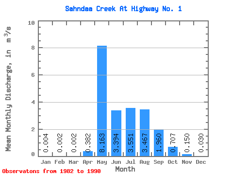
| Statistic | Jan | Feb | Mar | Apr | May | Jun | Jul | Aug | Sep | Oct | Nov | Dec | Annual |
|---|---|---|---|---|---|---|---|---|---|---|---|---|---|
| Mean | 0.00 | 0.00 | 0.00 | 0.38 | 8.16 | 3.39 | 3.55 | 3.47 | 1.96 | 0.71 | 0.15 | 0.03 | 1.82 |
| Standard Deviation | 0.01 | 0.00 | 0.00 | 0.43 | 4.09 | 2.17 | 4.13 | 4.32 | 2.55 | 0.62 | 0.16 | 0.04 | 1.04 |
| Min | 0.00 | 0.00 | 0.00 | 0.00 | 1.77 | 0.48 | 0.15 | 0.17 | 0.04 | 0.05 | 0.00 | 0.00 | 0.53 |
| Max | 0.01 | 0.01 | 0.01 | 1.36 | 15.20 | 7.44 | 13.90 | 11.60 | 8.14 | 1.88 | 0.49 | 0.09 | 3.95 |
| Coefficient of Variation | 1.44 | 1.32 | 1.94 | 1.14 | 0.50 | 0.64 | 1.16 | 1.25 | 1.30 | 0.87 | 1.06 | 1.18 | 0.57 |
 Return to R-Arctic Net Home Page