|
|
|||||||||||||||||
| Point ID: 3625 | Downloads | Plots | Site Data | Code: 10GC005 |
|
|
|||||||||||||||||
| Download | |
|---|---|
| Site Descriptor Information | Site Time Series Data |
| Link to all available data | |
| View: | Time Series | All |
| Units: | m3/s |
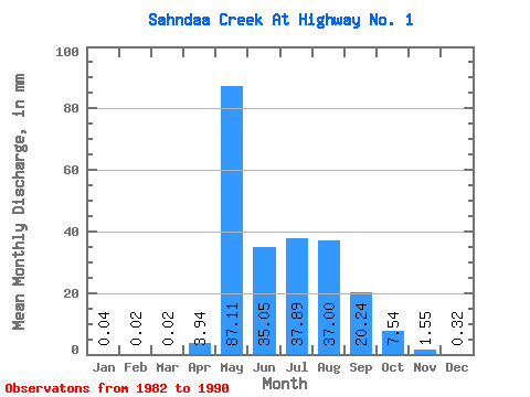
| Statistic | Jan | Feb | Mar | Apr | May | Jun | Jul | Aug | Sep | Oct | Nov | Dec | Annual |
|---|---|---|---|---|---|---|---|---|---|---|---|---|---|
| Mean | 0.04 | 0.02 | 0.02 | 3.95 | 87.10 | 35.05 | 37.89 | 36.99 | 20.24 | 7.55 | 1.55 | 0.32 | 228.55 |
| Standard Deviation | 0.06 | 0.03 | 0.04 | 4.49 | 43.68 | 22.36 | 44.10 | 46.06 | 26.35 | 6.58 | 1.64 | 0.37 | 130.89 |
| Min | 0.00 | 0.00 | 0.00 | 0.00 | 18.89 | 4.99 | 1.62 | 1.77 | 0.45 | 0.51 | 0.04 | 0.00 | 66.59 |
| Max | 0.15 | 0.07 | 0.11 | 14.04 | 162.17 | 76.83 | 148.30 | 123.76 | 84.06 | 20.06 | 5.10 | 0.91 | 496.72 |
| Coefficient of Variation | 1.44 | 1.32 | 1.94 | 1.14 | 0.50 | 0.64 | 1.16 | 1.25 | 1.30 | 0.87 | 1.06 | 1.18 | 0.57 |
 Return to R-Arctic Net Home Page