|
|
|||||||||||||||||
| Point ID: 3623 | Downloads | Plots | Site Data | Code: 10GC002 |
|
|
|||||||||||||||||
| Download | |
|---|---|
| Site Descriptor Information | Site Time Series Data |
| Link to all available data | |
| View: | Time Series | All |
| Units: | mm |
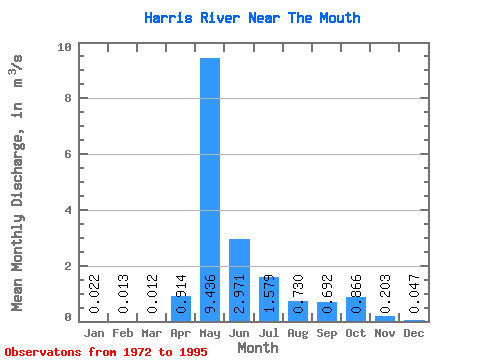
| Statistic | Jan | Feb | Mar | Apr | May | Jun | Jul | Aug | Sep | Oct | Nov | Dec | Annual |
|---|---|---|---|---|---|---|---|---|---|---|---|---|---|
| Mean | 0.02 | 0.01 | 0.01 | 0.91 | 9.44 | 2.97 | 1.58 | 0.73 | 0.69 | 0.87 | 0.20 | 0.05 | 1.46 |
| Standard Deviation | 0.04 | 0.04 | 0.04 | 1.54 | 6.16 | 2.09 | 2.96 | 1.53 | 1.12 | 1.50 | 0.41 | 0.07 | 0.85 |
| Min | 0.00 | 0.00 | 0.00 | 0.00 | 0.19 | 0.06 | 0.01 | 0.00 | 0.00 | 0.00 | 0.00 | 0.00 | 0.02 |
| Max | 0.17 | 0.16 | 0.20 | 5.90 | 24.10 | 8.68 | 14.40 | 7.32 | 4.48 | 6.84 | 1.91 | 0.22 | 3.27 |
| Coefficient of Variation | 2.00 | 2.63 | 3.33 | 1.69 | 0.65 | 0.70 | 1.88 | 2.09 | 1.62 | 1.73 | 2.00 | 1.61 | 0.58 |
 Return to R-Arctic Net Home Page