|
|
|||||||||||||||||
| Point ID: 3623 | Downloads | Plots | Site Data | Code: 10GC002 |
|
|
|||||||||||||||||
| Download | |
|---|---|
| Site Descriptor Information | Site Time Series Data |
| Link to all available data | |
| View: | Time Series | All |
| Units: | m3/s |
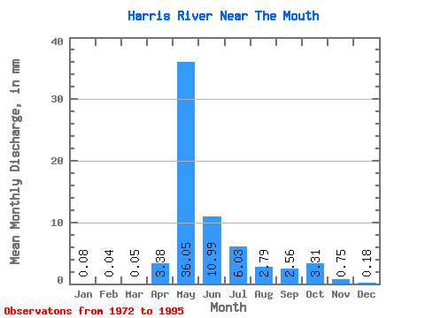
| Statistic | Jan | Feb | Mar | Apr | May | Jun | Jul | Aug | Sep | Oct | Nov | Dec | Annual |
|---|---|---|---|---|---|---|---|---|---|---|---|---|---|
| Mean | 0.08 | 0.05 | 0.05 | 3.38 | 36.05 | 10.99 | 6.03 | 2.79 | 2.56 | 3.31 | 0.75 | 0.18 | 65.65 |
| Standard Deviation | 0.17 | 0.12 | 0.16 | 5.70 | 23.54 | 7.74 | 11.32 | 5.84 | 4.15 | 5.73 | 1.50 | 0.29 | 38.16 |
| Min | 0.00 | 0.00 | 0.00 | 0.00 | 0.72 | 0.21 | 0.03 | 0.00 | 0.00 | 0.00 | 0.00 | 0.00 | 1.03 |
| Max | 0.63 | 0.56 | 0.75 | 21.82 | 92.07 | 32.09 | 55.01 | 27.96 | 16.57 | 26.13 | 7.06 | 0.85 | 147.28 |
| Coefficient of Variation | 2.00 | 2.63 | 3.33 | 1.69 | 0.65 | 0.70 | 1.88 | 2.09 | 1.62 | 1.73 | 2.00 | 1.61 | 0.58 |
 Return to R-Arctic Net Home Page