|
|
|||||||||||||||||
| Point ID: 3615 | Downloads | Plots | Site Data | Code: 10FB005 |
|
|
|||||||||||||||||
| Download | |
|---|---|
| Site Descriptor Information | Site Time Series Data |
| Link to all available data | |
| View: | Time Series | All |
| Units: | mm |
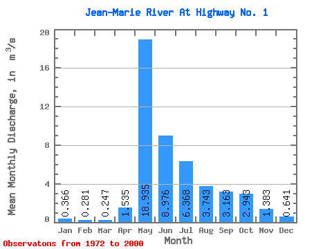
| Statistic | Jan | Feb | Mar | Apr | May | Jun | Jul | Aug | Sep | Oct | Nov | Dec | Annual |
|---|---|---|---|---|---|---|---|---|---|---|---|---|---|
| Mean | 0.37 | 0.28 | 0.25 | 1.54 | 18.93 | 8.98 | 6.37 | 3.74 | 3.16 | 2.94 | 1.38 | 0.64 | 4.06 |
| Standard Deviation | 0.16 | 0.14 | 0.14 | 1.91 | 11.19 | 6.05 | 10.56 | 3.65 | 3.25 | 2.65 | 1.12 | 0.38 | 1.99 |
| Min | 0.10 | 0.02 | 0.01 | 0.05 | 1.81 | 0.86 | 0.29 | 0.17 | 0.18 | 0.14 | 0.19 | 0.14 | 0.53 |
| Max | 0.64 | 0.55 | 0.64 | 8.42 | 44.00 | 23.00 | 56.40 | 17.10 | 12.40 | 11.60 | 4.69 | 1.46 | 9.86 |
| Coefficient of Variation | 0.44 | 0.51 | 0.57 | 1.25 | 0.59 | 0.67 | 1.66 | 0.97 | 1.03 | 0.90 | 0.81 | 0.60 | 0.49 |
 Return to R-Arctic Net Home Page