|
|
|||||||||||||||||
| Point ID: 3615 | Downloads | Plots | Site Data | Code: 10FB005 |
|
|
|||||||||||||||||
| Download | |
|---|---|
| Site Descriptor Information | Site Time Series Data |
| Link to all available data | |
| View: | Time Series | All |
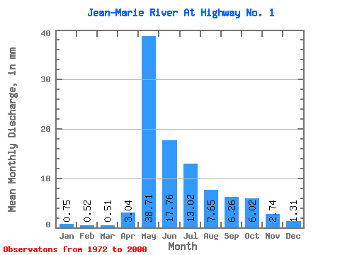
| Units: | m3/s |
| Statistic | Jan | Feb | Mar | Apr | May | Jun | Jul | Aug | Sep | Oct | Nov | Dec | Annual |
|---|---|---|---|---|---|---|---|---|---|---|---|---|---|
| Mean | 0.75 | 0.52 | 0.50 | 3.04 | 38.71 | 17.76 | 13.02 | 7.65 | 6.26 | 6.02 | 2.74 | 1.31 | 97.73 |
| Standard Deviation | 0.33 | 0.27 | 0.29 | 3.78 | 22.87 | 11.97 | 21.59 | 7.45 | 6.44 | 5.41 | 2.22 | 0.78 | 48.05 |
| Min | 0.20 | 0.03 | 0.02 | 0.10 | 3.70 | 1.70 | 0.60 | 0.34 | 0.35 | 0.29 | 0.37 | 0.29 | 12.69 |
| Max | 1.30 | 1.02 | 1.31 | 16.66 | 89.95 | 45.51 | 115.30 | 34.96 | 24.54 | 23.71 | 9.28 | 2.98 | 237.46 |
| Coefficient of Variation | 0.44 | 0.51 | 0.57 | 1.25 | 0.59 | 0.67 | 1.66 | 0.97 | 1.03 | 0.90 | 0.81 | 0.60 | 0.49 |
 Return to R-Arctic Net Home Page