|
|
|||||||||||||||||
| Point ID: 361 | Downloads | Plots | Site Data | Code: 05CA002 |
|
|
|||||||||||||||||
| Download | |
|---|---|
| Site Descriptor Information | Site Time Series Data |
| Link to all available data | |
| View: | Time Series | All |
| Units: | mm |
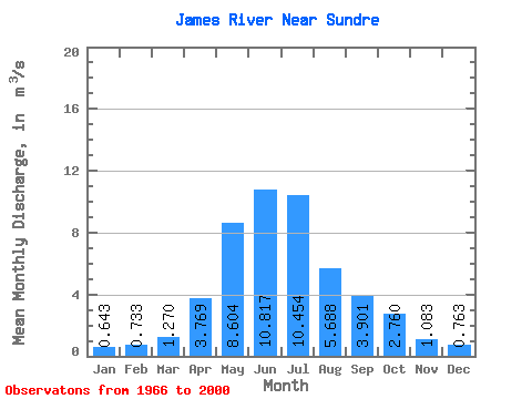
| Statistic | Jan | Feb | Mar | Apr | May | Jun | Jul | Aug | Sep | Oct | Nov | Dec | Annual |
|---|---|---|---|---|---|---|---|---|---|---|---|---|---|
| Mean | 0.64 | 0.73 | 1.27 | 3.77 | 8.60 | 10.82 | 10.45 | 5.69 | 3.90 | 2.76 | 1.08 | 0.76 | 2.94 |
| Standard Deviation | 0.17 | 0.30 | 0.46 | 1.59 | 5.35 | 6.60 | 8.84 | 3.43 | 2.38 | 1.80 | 0.39 | 0.28 | |
| Min | 0.52 | 0.43 | 0.66 | 1.56 | 1.74 | 1.87 | 1.63 | 1.08 | 1.20 | 1.24 | 0.71 | 0.46 | 2.94 |
| Max | 0.83 | 1.04 | 2.38 | 7.06 | 21.70 | 32.90 | 32.50 | 15.40 | 11.80 | 11.80 | 1.48 | 1.03 | 2.94 |
| Coefficient of Variation | 0.26 | 0.41 | 0.36 | 0.42 | 0.62 | 0.61 | 0.85 | 0.60 | 0.61 | 0.65 | 0.36 | 0.37 |
 Return to R-Arctic Net Home Page