|
|
|||||||||||||||||
| Point ID: 361 | Downloads | Plots | Site Data | Code: 05CA002 |
|
|
|||||||||||||||||
| Download | |
|---|---|
| Site Descriptor Information | Site Time Series Data |
| Link to all available data | |
| View: | Time Series | All |
| Units: | m3/s |
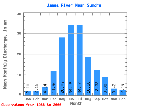
| Statistic | Jan | Feb | Mar | Apr | May | Jun | Jul | Aug | Sep | Oct | Nov | Dec | Annual |
|---|---|---|---|---|---|---|---|---|---|---|---|---|---|
| Mean | 2.10 | 2.18 | 4.14 | 11.90 | 28.07 | 34.15 | 34.10 | 18.55 | 12.32 | 9.00 | 3.42 | 2.49 | 112.93 |
| Standard Deviation | 0.55 | 0.90 | 1.49 | 5.02 | 17.44 | 20.84 | 28.84 | 11.19 | 7.50 | 5.86 | 1.22 | 0.93 | |
| Min | 1.69 | 1.29 | 2.15 | 4.92 | 5.68 | 5.90 | 5.32 | 3.52 | 3.79 | 4.04 | 2.24 | 1.51 | 112.93 |
| Max | 2.72 | 3.09 | 7.76 | 22.29 | 70.78 | 103.87 | 106.01 | 50.23 | 37.25 | 38.49 | 4.67 | 3.36 | 112.93 |
| Coefficient of Variation | 0.26 | 0.41 | 0.36 | 0.42 | 0.62 | 0.61 | 0.85 | 0.60 | 0.61 | 0.65 | 0.36 | 0.37 |
 Return to R-Arctic Net Home Page