|
|
|||||||||||||||||
| Point ID: 3602 | Downloads | Plots | Site Data | Code: 10EC001 |
|
|
|||||||||||||||||
| Download | |
|---|---|
| Site Descriptor Information | Site Time Series Data |
| Link to all available data | |
| View: | Time Series | All |
| Units: | mm |
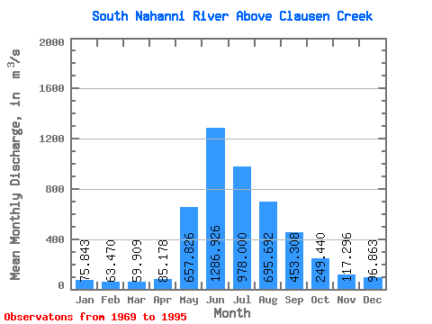
| Statistic | Jan | Feb | Mar | Apr | May | Jun | Jul | Aug | Sep | Oct | Nov | Dec | Annual |
|---|---|---|---|---|---|---|---|---|---|---|---|---|---|
| Mean | 75.84 | 63.47 | 59.91 | 85.18 | 657.83 | 1286.93 | 978.00 | 695.69 | 453.31 | 249.44 | 117.30 | 96.86 | 402.17 |
| Standard Deviation | 11.54 | 9.58 | 8.99 | 26.62 | 152.18 | 260.78 | 243.24 | 147.08 | 97.67 | 56.98 | 21.26 | 16.39 | 44.23 |
| Min | 52.60 | 46.10 | 45.40 | 52.20 | 368.00 | 855.00 | 640.00 | 454.00 | 309.00 | 185.00 | 78.00 | 68.70 | 334.18 |
| Max | 98.70 | 90.70 | 88.50 | 155.00 | 907.00 | 2120.00 | 1600.00 | 1130.00 | 716.00 | 362.00 | 171.00 | 135.00 | 504.57 |
| Coefficient of Variation | 0.15 | 0.15 | 0.15 | 0.31 | 0.23 | 0.20 | 0.25 | 0.21 | 0.21 | 0.23 | 0.18 | 0.17 | 0.11 |
 Return to R-Arctic Net Home Page