|
|
|||||||||||||||||
| Point ID: 3602 | Downloads | Plots | Site Data | Code: 10EC001 |
|
|
|||||||||||||||||
| Download | |
|---|---|
| Site Descriptor Information | Site Time Series Data |
| Link to all available data | |
| View: | Time Series | All |
| Units: | m3/s |
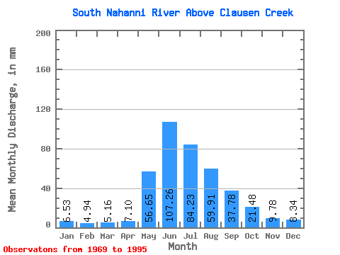
| Statistic | Jan | Feb | Mar | Apr | May | Jun | Jul | Aug | Sep | Oct | Nov | Dec | Annual |
|---|---|---|---|---|---|---|---|---|---|---|---|---|---|
| Mean | 6.53 | 4.98 | 5.16 | 7.10 | 56.65 | 107.26 | 84.22 | 59.91 | 37.78 | 21.48 | 9.78 | 8.34 | 408.12 |
| Standard Deviation | 0.99 | 0.75 | 0.77 | 2.22 | 13.10 | 21.73 | 20.95 | 12.66 | 8.14 | 4.91 | 1.77 | 1.41 | 44.89 |
| Min | 4.53 | 3.62 | 3.91 | 4.35 | 31.69 | 71.26 | 55.11 | 39.09 | 25.75 | 15.93 | 6.50 | 5.92 | 339.12 |
| Max | 8.50 | 7.12 | 7.62 | 12.92 | 78.10 | 176.69 | 137.78 | 97.30 | 59.67 | 31.17 | 14.25 | 11.62 | 512.04 |
| Coefficient of Variation | 0.15 | 0.15 | 0.15 | 0.31 | 0.23 | 0.20 | 0.25 | 0.21 | 0.21 | 0.23 | 0.18 | 0.17 | 0.11 |
 Return to R-Arctic Net Home Page