|
|
|||||||||||||||||
| Point ID: 3587 | Downloads | Plots | Site Data | Code: 07SB009 |
|
|
|||||||||||||||||
| Download | |
|---|---|
| Site Descriptor Information | Site Time Series Data |
| Link to all available data | |
| View: | Time Series | All |
| Units: | mm |
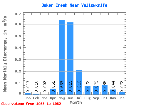
| Statistic | Jan | Feb | Mar | Apr | May | Jun | Jul | Aug | Sep | Oct | Nov | Dec | Annual |
|---|---|---|---|---|---|---|---|---|---|---|---|---|---|
| Mean | 0.02 | 0.01 | 0.00 | 0.05 | 0.64 | 0.61 | 0.21 | 0.07 | 0.07 | 0.09 | 0.04 | 0.02 | 0.14 |
| Standard Deviation | 0.05 | 0.03 | 0.00 | 0.08 | 0.69 | 0.24 | 0.14 | 0.11 | 0.14 | 0.16 | 0.11 | 0.06 | 0.09 |
| Min | 0.00 | 0.00 | 0.00 | 0.00 | 0.18 | 0.15 | 0.06 | 0.00 | 0.00 | 0.00 | 0.00 | 0.00 | 0.04 |
| Max | 0.17 | 0.10 | 0.01 | 0.22 | 2.67 | 1.03 | 0.64 | 0.46 | 0.42 | 0.47 | 0.38 | 0.19 | 0.33 |
| Coefficient of Variation | 2.92 | 2.96 | 1.94 | 1.62 | 1.07 | 0.39 | 0.67 | 1.57 | 1.95 | 1.93 | 2.55 | 2.54 | 0.65 |
 Return to R-Arctic Net Home Page