|
|
|||||||||||||||||
| Point ID: 3587 | Downloads | Plots | Site Data | Code: 07SB009 |
|
|
|||||||||||||||||
| Download | |
|---|---|
| Site Descriptor Information | Site Time Series Data |
| Link to all available data | |
| View: | Time Series | All |
| Units: | m3/s |
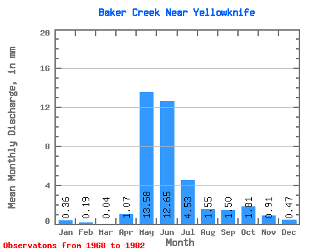
| Statistic | Jan | Feb | Mar | Apr | May | Jun | Jul | Aug | Sep | Oct | Nov | Dec | Annual |
|---|---|---|---|---|---|---|---|---|---|---|---|---|---|
| Mean | 0.37 | 0.19 | 0.04 | 1.07 | 13.58 | 12.64 | 4.52 | 1.55 | 1.51 | 1.81 | 0.90 | 0.47 | 36.43 |
| Standard Deviation | 1.07 | 0.55 | 0.08 | 1.73 | 14.58 | 4.95 | 3.02 | 2.43 | 2.95 | 3.48 | 2.28 | 1.21 | 23.57 |
| Min | 0.00 | 0.00 | 0.00 | 0.00 | 3.85 | 3.17 | 1.34 | 0.04 | 0.02 | 0.04 | 0.00 | 0.00 | 9.23 |
| Max | 3.57 | 1.84 | 0.23 | 4.57 | 56.75 | 21.19 | 13.60 | 9.71 | 8.68 | 9.97 | 7.74 | 4.06 | 83.14 |
| Coefficient of Variation | 2.92 | 2.96 | 1.94 | 1.62 | 1.07 | 0.39 | 0.67 | 1.57 | 1.95 | 1.93 | 2.55 | 2.54 | 0.65 |
 Return to R-Arctic Net Home Page