|
|
|||||||||||||||||
| Point ID: 3545 | Downloads | Plots | Site Data | Code: 06NC001 |
|
|
|||||||||||||||||
| Download | |
|---|---|
| Site Descriptor Information | Site Time Series Data |
| Link to all available data | |
| View: | Time Series | All |
| Units: | mm |
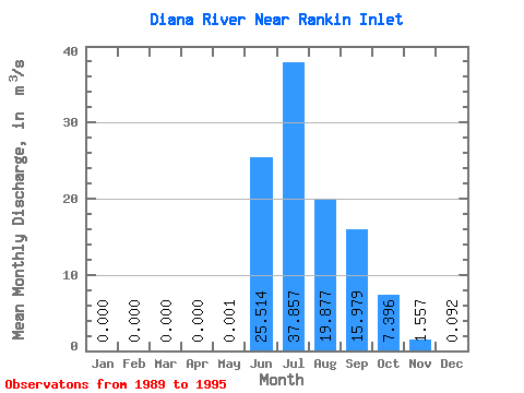
| Statistic | Jan | Feb | Mar | Apr | May | Jun | Jul | Aug | Sep | Oct | Nov | Dec | Annual |
|---|---|---|---|---|---|---|---|---|---|---|---|---|---|
| Mean | 0.00 | 0.00 | 0.00 | 0.00 | 0.00 | 25.51 | 37.86 | 19.88 | 15.98 | 7.40 | 1.56 | 0.09 | 9.02 |
| Standard Deviation | 0.00 | 0.00 | 0.00 | 0.00 | 0.00 | 16.75 | 12.69 | 6.68 | 8.66 | 2.80 | 0.77 | 0.06 | 2.47 |
| Min | 0.00 | 0.00 | 0.00 | 0.00 | 0.00 | 10.00 | 23.50 | 9.34 | 7.39 | 3.35 | 0.69 | 0.01 | 6.29 |
| Max | 0.00 | 0.00 | 0.00 | 0.00 | 0.00 | 59.50 | 59.30 | 29.50 | 32.50 | 11.70 | 2.60 | 0.19 | 12.44 |
| Coefficient of Variation | 1.41 | 0.66 | 0.34 | 0.34 | 0.54 | 0.38 | 0.49 | 0.64 | 0.27 |
 Return to R-Arctic Net Home Page