|
|
|||||||||||||||||
| Point ID: 3545 | Downloads | Plots | Site Data | Code: 06NC001 |
|
|
|||||||||||||||||
| Download | |
|---|---|
| Site Descriptor Information | Site Time Series Data |
| Link to all available data | |
| View: | Time Series | All |
| Units: | m3/s |
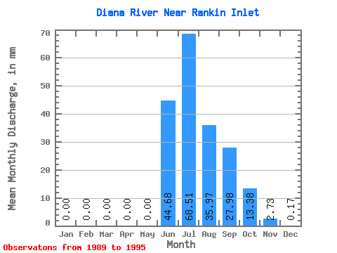
| Statistic | Jan | Feb | Mar | Apr | May | Jun | Jul | Aug | Sep | Oct | Nov | Dec | Annual |
|---|---|---|---|---|---|---|---|---|---|---|---|---|---|
| Mean | 0.00 | 0.00 | 0.00 | 0.00 | 0.00 | 44.68 | 68.50 | 35.97 | 27.98 | 13.38 | 2.73 | 0.17 | 192.40 |
| Standard Deviation | 0.00 | 0.00 | 0.00 | 0.00 | 0.00 | 29.33 | 22.95 | 12.09 | 15.17 | 5.08 | 1.34 | 0.11 | 52.69 |
| Min | 0.00 | 0.00 | 0.00 | 0.00 | 0.00 | 17.51 | 42.52 | 16.90 | 12.94 | 6.06 | 1.21 | 0.01 | 134.12 |
| Max | 0.00 | 0.00 | 0.00 | 0.00 | 0.01 | 104.20 | 107.30 | 53.38 | 56.92 | 21.17 | 4.55 | 0.34 | 265.21 |
| Coefficient of Variation | 1.41 | 0.66 | 0.34 | 0.34 | 0.54 | 0.38 | 0.49 | 0.64 | 0.27 |
 Return to R-Arctic Net Home Page