|
|
|||||||||||||||||
| Point ID: 3540 | Downloads | Plots | Site Data | Code: 06MA005 |
|
|
|||||||||||||||||
| Download | |
|---|---|
| Site Descriptor Information | Site Time Series Data |
| Link to all available data | |
| View: | Time Series | All |
| Units: | mm |
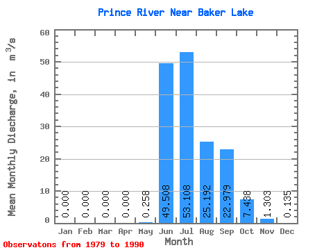
| Statistic | Jan | Feb | Mar | Apr | May | Jun | Jul | Aug | Sep | Oct | Nov | Dec | Annual |
|---|---|---|---|---|---|---|---|---|---|---|---|---|---|
| Mean | 0.00 | 0.00 | 0.00 | 0.00 | 0.26 | 49.51 | 53.11 | 25.19 | 22.98 | 7.44 | 1.30 | 0.14 | 11.86 |
| Standard Deviation | 0.00 | 0.00 | 0.00 | 0.00 | 0.61 | 19.80 | 16.43 | 7.51 | 11.76 | 5.68 | 1.32 | 0.16 | 2.16 |
| Min | 0.00 | 0.00 | 0.00 | 0.00 | 0.00 | 18.60 | 31.00 | 13.50 | 5.73 | 0.07 | 0.00 | 0.00 | 9.44 |
| Max | 0.00 | 0.00 | 0.00 | 0.00 | 1.81 | 76.30 | 91.10 | 38.00 | 45.50 | 18.30 | 4.21 | 0.44 | 13.69 |
| Coefficient of Variation | 2.37 | 0.40 | 0.31 | 0.30 | 0.51 | 0.76 | 1.02 | 1.20 | 0.18 |
 Return to R-Arctic Net Home Page