|
|
|||||||||||||||||
| Point ID: 3540 | Downloads | Plots | Site Data | Code: 06MA005 |
|
|
|||||||||||||||||
| Download | |
|---|---|
| Site Descriptor Information | Site Time Series Data |
| Link to all available data | |
| View: | Time Series | All |
| Units: | m3/s |
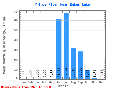
| Statistic | Jan | Feb | Mar | Apr | May | Jun | Jul | Aug | Sep | Oct | Nov | Dec | Annual |
|---|---|---|---|---|---|---|---|---|---|---|---|---|---|
| Mean | 0.00 | 0.00 | 0.00 | 0.00 | 0.33 | 61.11 | 67.73 | 32.12 | 28.36 | 9.49 | 1.61 | 0.17 | 178.19 |
| Standard Deviation | 0.00 | 0.00 | 0.00 | 0.00 | 0.78 | 24.44 | 20.96 | 9.57 | 14.52 | 7.25 | 1.63 | 0.21 | 32.42 |
| Min | 0.00 | 0.00 | 0.00 | 0.00 | 0.00 | 22.96 | 39.53 | 17.22 | 7.07 | 0.09 | 0.00 | 0.00 | 141.91 |
| Max | 0.00 | 0.00 | 0.00 | 0.00 | 2.31 | 94.18 | 116.17 | 48.46 | 56.16 | 23.34 | 5.20 | 0.56 | 205.68 |
| Coefficient of Variation | 2.37 | 0.40 | 0.31 | 0.30 | 0.51 | 0.76 | 1.02 | 1.20 | 0.18 |
 Return to R-Arctic Net Home Page