|
|
|||||||||||||||||
| Point ID: 330 | Downloads | Plots | Site Data | Code: 05BM008 |
|
|
|||||||||||||||||
| Download | |
|---|---|
| Site Descriptor Information | Site Time Series Data |
| Link to all available data | |
| View: | Time Series | All |
| Units: | mm |
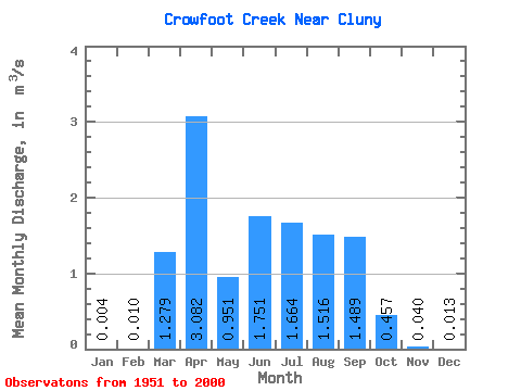
| Statistic | Jan | Feb | Mar | Apr | May | Jun | Jul | Aug | Sep | Oct | Nov | Dec | Annual |
|---|---|---|---|---|---|---|---|---|---|---|---|---|---|
| Mean | 0.00 | 0.01 | 1.28 | 3.08 | 0.95 | 1.75 | 1.66 | 1.52 | 1.49 | 0.46 | 0.04 | 0.01 | 1.25 |
| Standard Deviation | 0.01 | 0.01 | 1.88 | 4.88 | 0.46 | 1.38 | 0.91 | 0.46 | 0.52 | 0.20 | 0.02 | 0.01 | 0.56 |
| Min | 0.00 | 0.00 | 0.00 | 0.04 | 0.24 | 0.66 | 0.71 | 0.72 | 0.67 | 0.15 | 0.02 | 0.00 | 0.65 |
| Max | 0.03 | 0.04 | 7.88 | 19.70 | 2.50 | 10.50 | 6.21 | 2.63 | 3.00 | 1.07 | 0.07 | 0.03 | 1.83 |
| Coefficient of Variation | 2.33 | 1.32 | 1.47 | 1.58 | 0.48 | 0.79 | 0.55 | 0.31 | 0.35 | 0.44 | 0.40 | 0.63 | 0.45 |
 Return to R-Arctic Net Home Page