|
|
|||||||||||||||||
| Point ID: 330 | Downloads | Plots | Site Data | Code: 05BM008 |
|
|
|||||||||||||||||
| Download | |
|---|---|
| Site Descriptor Information | Site Time Series Data |
| Link to all available data | |
| View: | Time Series | All |
| Units: | m3/s |
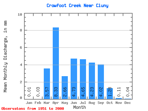
| Statistic | Jan | Feb | Mar | Apr | May | Jun | Jul | Aug | Sep | Oct | Nov | Dec | Annual |
|---|---|---|---|---|---|---|---|---|---|---|---|---|---|
| Mean | 0.01 | 0.02 | 2.52 | 5.87 | 1.87 | 3.34 | 3.28 | 2.98 | 2.84 | 0.90 | 0.08 | 0.03 | 28.93 |
| Standard Deviation | 0.02 | 0.02 | 3.70 | 9.30 | 0.91 | 2.63 | 1.79 | 0.91 | 0.99 | 0.40 | 0.03 | 0.02 | 12.87 |
| Min | 0.00 | 0.00 | 0.00 | 0.08 | 0.47 | 1.25 | 1.40 | 1.43 | 1.27 | 0.29 | 0.04 | 0.01 | 15.15 |
| Max | 0.05 | 0.07 | 15.52 | 37.55 | 4.92 | 20.01 | 12.23 | 5.18 | 5.72 | 2.11 | 0.13 | 0.05 | 42.53 |
| Coefficient of Variation | 2.33 | 1.32 | 1.47 | 1.58 | 0.48 | 0.79 | 0.55 | 0.31 | 0.35 | 0.44 | 0.40 | 0.63 | 0.45 |
 Return to R-Arctic Net Home Page