|
|
|||||||||||||||||
| Point ID: 324 | Downloads | Plots | Site Data | Code: 05BM002 |
|
|
|||||||||||||||||
| Download | |
|---|---|
| Site Descriptor Information | Site Time Series Data |
| Link to all available data | |
| View: | Time Series | All |
| Units: | mm |
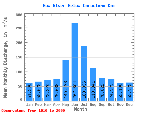
| Statistic | Jan | Feb | Mar | Apr | May | Jun | Jul | Aug | Sep | Oct | Nov | Dec | Annual |
|---|---|---|---|---|---|---|---|---|---|---|---|---|---|
| Mean | 61.30 | 65.67 | 72.32 | 75.64 | 140.49 | 267.30 | 189.04 | 113.34 | 78.62 | 74.98 | 62.10 | 62.98 | 107.94 |
| Standard Deviation | 6.55 | 1.88 | 5.67 | 23.28 | 52.48 | 105.73 | 79.41 | 45.75 | 28.93 | 24.31 | 8.18 | 4.49 | 20.12 |
| Min | 54.00 | 63.90 | 63.60 | 38.50 | 42.50 | 82.00 | 76.40 | 57.10 | 35.00 | 35.10 | 54.70 | 58.20 | 94.58 |
| Max | 69.80 | 67.80 | 78.90 | 145.00 | 273.00 | 554.00 | 385.00 | 248.00 | 165.00 | 147.00 | 73.60 | 68.90 | 131.07 |
| Coefficient of Variation | 0.11 | 0.03 | 0.08 | 0.31 | 0.37 | 0.40 | 0.42 | 0.40 | 0.37 | 0.32 | 0.13 | 0.07 | 0.19 |
 Return to R-Arctic Net Home Page