|
|
|||||||||||||||||
| Point ID: 324 | Downloads | Plots | Site Data | Code: 05BM002 |
|
|
|||||||||||||||||
| Download | |
|---|---|
| Site Descriptor Information | Site Time Series Data |
| Link to all available data | |
| View: | Time Series | All |
| Units: | m3/s |
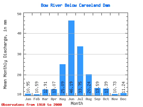
| Statistic | Jan | Feb | Mar | Apr | May | Jun | Jul | Aug | Sep | Oct | Nov | Dec | Annual |
|---|---|---|---|---|---|---|---|---|---|---|---|---|---|
| Mean | 10.46 | 10.21 | 12.34 | 12.49 | 23.96 | 44.13 | 32.24 | 19.33 | 12.98 | 12.79 | 10.25 | 10.74 | 216.97 |
| Standard Deviation | 1.12 | 0.29 | 0.97 | 3.84 | 8.95 | 17.46 | 13.54 | 7.80 | 4.78 | 4.15 | 1.35 | 0.77 | 40.44 |
| Min | 9.21 | 9.93 | 10.85 | 6.36 | 7.25 | 13.54 | 13.03 | 9.74 | 5.78 | 5.99 | 9.03 | 9.93 | 190.13 |
| Max | 11.91 | 10.54 | 13.46 | 23.94 | 46.57 | 91.46 | 65.67 | 42.30 | 27.24 | 25.07 | 12.15 | 11.75 | 263.49 |
| Coefficient of Variation | 0.11 | 0.03 | 0.08 | 0.31 | 0.37 | 0.40 | 0.42 | 0.40 | 0.37 | 0.32 | 0.13 | 0.07 | 0.19 |
 Return to R-Arctic Net Home Page