|
|
|||||||||||||||||
| Point ID: 316 | Downloads | Plots | Site Data | Code: 05BL019 |
|
|
|||||||||||||||||
| Download | |
|---|---|
| Site Descriptor Information | Site Time Series Data |
| Link to all available data | |
| View: | Time Series | All |
| Units: | mm |
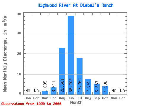
| Statistic | Jan | Feb | Mar | Apr | May | Jun | Jul | Aug | Sep | Oct | Nov | Dec | Annual |
|---|---|---|---|---|---|---|---|---|---|---|---|---|---|
| Mean | 1.69 | 3.51 | 22.56 | 38.20 | 17.76 | 7.55 | 5.37 | 4.40 | |||||
| Standard Deviation | 0.37 | 1.55 | 8.34 | 16.07 | 8.53 | 3.03 | 2.94 | 2.16 | |||||
| Min | 0.76 | 1.62 | 8.75 | 11.90 | 4.73 | 4.27 | 2.96 | 2.48 | |||||
| Max | 2.71 | 9.13 | 41.40 | 87.00 | 46.80 | 19.50 | 20.40 | 14.00 | |||||
| Coefficient of Variation | 0.22 | 0.44 | 0.37 | 0.42 | 0.48 | 0.40 | 0.55 | 0.49 |
 Return to R-Arctic Net Home Page