|
|
|||||||||||||||||
| Point ID: 316 | Downloads | Plots | Site Data | Code: 05BL019 |
|
|
|||||||||||||||||
| Download | |
|---|---|
| Site Descriptor Information | Site Time Series Data |
| Link to all available data | |
| View: | Time Series | All |
| Units: | m3/s |
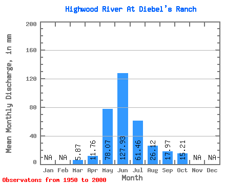
| Statistic | Jan | Feb | Mar | Apr | May | Jun | Jul | Aug | Sep | Oct | Nov | Dec | Annual |
|---|---|---|---|---|---|---|---|---|---|---|---|---|---|
| Mean | 5.87 | 11.76 | 78.06 | 127.93 | 61.45 | 26.12 | 17.98 | 15.21 | |||||
| Standard Deviation | 1.27 | 5.20 | 28.84 | 53.80 | 29.51 | 10.49 | 9.84 | 7.46 | |||||
| Min | 2.63 | 5.42 | 30.27 | 39.85 | 16.37 | 14.77 | 9.91 | 8.58 | |||||
| Max | 9.38 | 30.57 | 143.24 | 291.35 | 161.93 | 67.47 | 68.32 | 48.44 | |||||
| Coefficient of Variation | 0.22 | 0.44 | 0.37 | 0.42 | 0.48 | 0.40 | 0.55 | 0.49 |
 Return to R-Arctic Net Home Page