|
|
|||||||||||||||||
| Point ID: 315 | Downloads | Plots | Site Data | Code: 05BL018 |
|
|
|||||||||||||||||
| Download | |
|---|---|
| Site Descriptor Information | Site Time Series Data |
| Link to all available data | |
| View: | Time Series | All |
| Units: | mm |
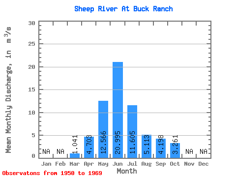
| Statistic | Jan | Feb | Mar | Apr | May | Jun | Jul | Aug | Sep | Oct | Nov | Dec | Annual |
|---|---|---|---|---|---|---|---|---|---|---|---|---|---|
| Mean | 1.04 | 4.70 | 12.57 | 21.00 | 11.61 | 5.11 | 4.20 | 3.26 | |||||
| Standard Deviation | 0.55 | 4.33 | 4.18 | 9.21 | 6.26 | 2.45 | 3.89 | 2.13 | |||||
| Min | 0.55 | 1.02 | 5.63 | 11.10 | 3.99 | 2.62 | 1.97 | 1.54 | |||||
| Max | 2.89 | 14.00 | 19.10 | 43.20 | 26.30 | 11.70 | 19.80 | 8.97 | |||||
| Coefficient of Variation | 0.53 | 0.92 | 0.33 | 0.44 | 0.54 | 0.48 | 0.93 | 0.65 |
 Return to R-Arctic Net Home Page