|
|
|||||||||||||||||
| Point ID: 315 | Downloads | Plots | Site Data | Code: 05BL018 |
|
|
|||||||||||||||||
| Download | |
|---|---|
| Site Descriptor Information | Site Time Series Data |
| Link to all available data | |
| View: | Time Series | All |
| Units: | m3/s |
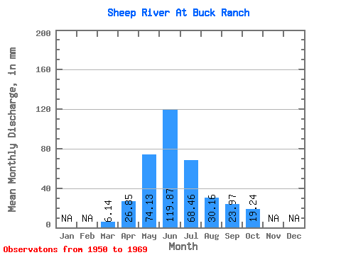
| Statistic | Jan | Feb | Mar | Apr | May | Jun | Jul | Aug | Sep | Oct | Nov | Dec | Annual |
|---|---|---|---|---|---|---|---|---|---|---|---|---|---|
| Mean | 6.14 | 26.85 | 74.12 | 119.86 | 68.45 | 30.16 | 23.97 | 19.23 | |||||
| Standard Deviation | 3.26 | 24.70 | 24.67 | 52.61 | 36.94 | 14.48 | 22.23 | 12.59 | |||||
| Min | 3.26 | 5.82 | 33.21 | 63.37 | 23.54 | 15.46 | 11.25 | 9.08 | |||||
| Max | 17.05 | 79.93 | 112.67 | 246.64 | 155.13 | 69.02 | 113.04 | 52.91 | |||||
| Coefficient of Variation | 0.53 | 0.92 | 0.33 | 0.44 | 0.54 | 0.48 | 0.93 | 0.65 |
 Return to R-Arctic Net Home Page