|
|
|||||||||||||||||
| Point ID: 3116 | Downloads | Plots | Site Data | Code: 05UG001 |
|
|
|||||||||||||||||
| Download | |
|---|---|
| Site Descriptor Information | Site Time Series Data |
| Link to all available data | |
| View: | Time Series | All |
| Units: | mm |
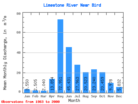
| Statistic | Jan | Feb | Mar | Apr | May | Jun | Jul | Aug | Sep | Oct | Nov | Dec | Annual |
|---|---|---|---|---|---|---|---|---|---|---|---|---|---|
| Mean | 3.55 | 2.50 | 2.04 | 13.85 | 72.95 | 45.43 | 27.96 | 20.52 | 23.24 | 20.46 | 9.98 | 5.83 | 21.54 |
| Standard Deviation | 1.61 | 1.17 | 1.10 | 19.88 | 32.72 | 25.93 | 19.31 | 17.83 | 18.03 | 14.58 | 4.12 | 2.91 | 6.39 |
| Min | 1.54 | 0.99 | 0.59 | 0.99 | 9.08 | 16.20 | 8.85 | 1.72 | 2.09 | 6.30 | 4.79 | 2.66 | 11.02 |
| Max | 8.75 | 6.27 | 6.23 | 69.80 | 144.00 | 154.00 | 108.00 | 69.30 | 78.90 | 80.70 | 19.30 | 16.70 | 39.26 |
| Coefficient of Variation | 0.45 | 0.47 | 0.54 | 1.44 | 0.45 | 0.57 | 0.69 | 0.87 | 0.78 | 0.71 | 0.41 | 0.50 | 0.30 |
 Return to R-Arctic Net Home Page