|
|
|||||||||||||||||
| Point ID: 3116 | Downloads | Plots | Site Data | Code: 05UG001 |
|
|
|||||||||||||||||
| Download | |
|---|---|
| Site Descriptor Information | Site Time Series Data |
| Link to all available data | |
| View: | Time Series | All |
| Units: | m3/s |
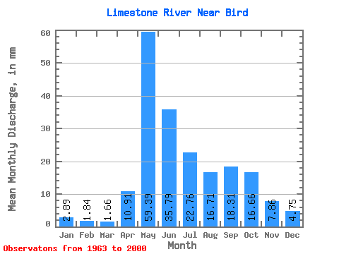
| Statistic | Jan | Feb | Mar | Apr | May | Jun | Jul | Aug | Sep | Oct | Nov | Dec | Annual |
|---|---|---|---|---|---|---|---|---|---|---|---|---|---|
| Mean | 2.89 | 1.86 | 1.66 | 10.91 | 59.38 | 35.79 | 22.76 | 16.70 | 18.31 | 16.65 | 7.86 | 4.75 | 206.65 |
| Standard Deviation | 1.31 | 0.87 | 0.90 | 15.66 | 26.63 | 20.43 | 15.72 | 14.51 | 14.20 | 11.87 | 3.25 | 2.37 | 61.25 |
| Min | 1.25 | 0.73 | 0.48 | 0.78 | 7.39 | 12.76 | 7.20 | 1.40 | 1.65 | 5.13 | 3.77 | 2.17 | 105.70 |
| Max | 7.12 | 4.65 | 5.07 | 54.99 | 117.21 | 121.33 | 87.91 | 56.41 | 62.16 | 65.69 | 15.21 | 13.59 | 376.60 |
| Coefficient of Variation | 0.45 | 0.47 | 0.54 | 1.44 | 0.45 | 0.57 | 0.69 | 0.87 | 0.78 | 0.71 | 0.41 | 0.50 | 0.30 |
 Return to R-Arctic Net Home Page