|
|
|||||||||||||||||
| Point ID: 3099 | Downloads | Plots | Site Data | Code: 05TF002 |
|
|
|||||||||||||||||
| Download | |
|---|---|
| Site Descriptor Information | Site Time Series Data |
| Link to all available data | |
| View: | Time Series | All |
| Units: | mm |
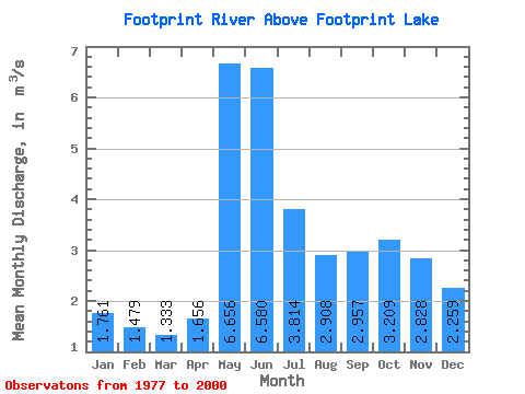
| Statistic | Jan | Feb | Mar | Apr | May | Jun | Jul | Aug | Sep | Oct | Nov | Dec | Annual |
|---|---|---|---|---|---|---|---|---|---|---|---|---|---|
| Mean | 1.76 | 1.48 | 1.33 | 1.66 | 6.66 | 6.58 | 3.81 | 2.91 | 2.96 | 3.21 | 2.83 | 2.26 | 3.07 |
| Standard Deviation | 0.62 | 0.49 | 0.47 | 0.56 | 3.20 | 3.13 | 2.19 | 1.93 | 2.56 | 3.21 | 2.39 | 1.23 | 1.02 |
| Min | 0.84 | 0.75 | 0.62 | 0.94 | 2.39 | 1.41 | 0.51 | 0.26 | 0.23 | 0.29 | 0.52 | 0.71 | 1.02 |
| Max | 2.88 | 2.46 | 2.37 | 3.12 | 12.40 | 11.50 | 8.71 | 7.69 | 7.90 | 11.10 | 10.20 | 6.02 | 4.79 |
| Coefficient of Variation | 0.35 | 0.33 | 0.35 | 0.34 | 0.48 | 0.47 | 0.57 | 0.66 | 0.86 | 1.00 | 0.84 | 0.55 | 0.33 |
 Return to R-Arctic Net Home Page