|
|
|||||||||||||||||
| Point ID: 3099 | Downloads | Plots | Site Data | Code: 05TF002 |
|
|
|||||||||||||||||
| Download | |
|---|---|
| Site Descriptor Information | Site Time Series Data |
| Link to all available data | |
| View: | Time Series | All |
| Units: | m3/s |
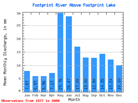
| Statistic | Jan | Feb | Mar | Apr | May | Jun | Jul | Aug | Sep | Oct | Nov | Dec | Annual |
|---|---|---|---|---|---|---|---|---|---|---|---|---|---|
| Mean | 7.87 | 6.03 | 5.96 | 7.17 | 29.76 | 28.47 | 17.05 | 13.00 | 12.80 | 14.35 | 12.24 | 10.10 | 161.91 |
| Standard Deviation | 2.79 | 1.99 | 2.09 | 2.44 | 14.32 | 13.53 | 9.78 | 8.63 | 11.06 | 14.35 | 10.35 | 5.50 | 53.84 |
| Min | 3.76 | 3.06 | 2.77 | 4.05 | 10.69 | 6.10 | 2.29 | 1.17 | 1.01 | 1.32 | 2.23 | 3.17 | 53.71 |
| Max | 12.88 | 10.02 | 10.60 | 13.50 | 55.44 | 49.76 | 38.94 | 34.38 | 34.19 | 49.63 | 44.14 | 26.91 | 252.42 |
| Coefficient of Variation | 0.35 | 0.33 | 0.35 | 0.34 | 0.48 | 0.47 | 0.57 | 0.66 | 0.86 | 1.00 | 0.84 | 0.55 | 0.33 |
 Return to R-Arctic Net Home Page